
 The pie or radial patterned towns and fields
 ^Click this text to enlarge^
 The rectilinear soybean fields funded by foreign loans
These images from Landsat7, acquired on August 1, 2000, shows the new agricultural settlements east of Santa Cruz de la Sierra, Bolivia in an area of tropical dry forest. Since the mid-1980s, this region has been rapidly deforested as a result of the resettlement of people from the Altiplano (the Andean high plains) and a large agricultural development effort, called the Tierras Baja project. The pie or radial patterned fields (top) are part of the San Javier resettlement scheme. At the center of each unit is a small community including a church, bar/cafe, school, and soccer field-the essentials of life in rural Bolivia. The rectilinear, light-colored areas (above) are fields of soybeans cultivated for export that are mostly funded by foreign loans. The dark strips running through these fields are wind breaks. These are advantageous because the soils in this area are fine and prone to wind erosion.
The eastern half of Bolivia is covered with tropical rainforest. In the 1990s, Bolivia initiated a large-scale effort to increase the rate of logging and create tracts of land for commercial agriculture (primarily soy and sugar cane, but also cocoa) on the Amazon Basin side of the Andean highlands. Today, the commercial fields are well established and easily mapped from space as large, rectangular clearings in the forest. The agricultural developments are still growing today. The clearings start off as small rectangles arranged perpendicular to an access road; early clearings take on a herringbone pattern when viewed from above. The intact areas (dark forest) are gradually logged and then cultivated, filling in the pattern to make a larger cleared area.
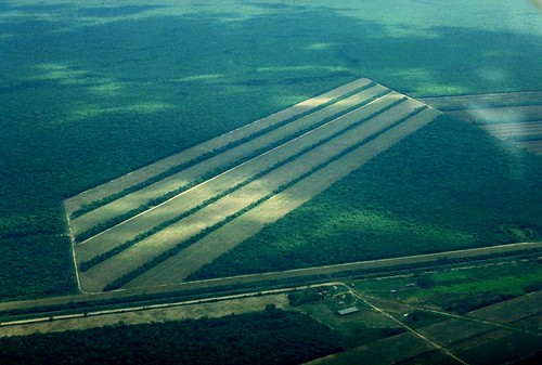
Astronauts aboard the International Space Station (ISS) routinely observe intensive land use and document their observations through imagery so that changes can be identified. These two photographs (below) of the Bolivian forest along the Rio Parapetí in Bolivia (south of Santa Cruz, not shown) show different stages of the clearing process and agricultural field development. The top image, a wide panoramic view looking toward the west and the Andean foothills, was taken from the Space Shuttle in November 1995. The clearing efforts were just getting underway, evidenced by the crosshatched and herringbone pattern of clearing north of the river. On the south side of the river, old, abandoned stream channels show up as lighter regions with lesser forest cover.
The bottom view, a composite of two images taken from the ISS, provides a more detailed view of today’s landscape, showing completely cleared regions that stretch for more than 10 kilometers. For scale, the white line is about 12 kilometers (7.5 miles). The geographic area covered in the 2008 view is approximated on the top image by the white box.
 Before
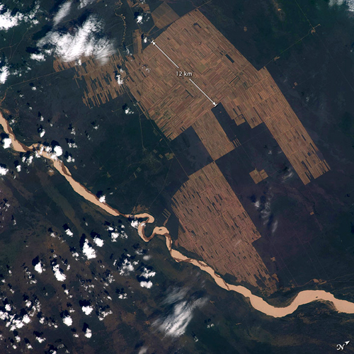 After
AfterSource: NASA
No comments:
Post a Comment